ARES
Understanding measurement data. Supporting decisions in the field.
How UseTree developed the UX concept for the mixed reality application in the ARES research project. Helping explosive ordnance specialists access information exactly where they need it.
Sector
Industrial Manufacturing
Period
07.2022 - 12.2025
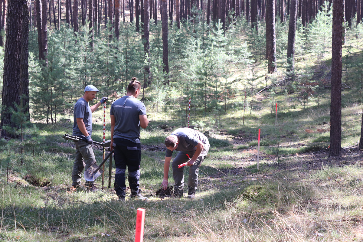
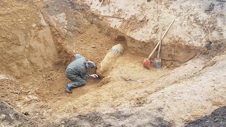
Many regions across Europe still contain buried explosive ordnance left behind by past wars or military exercises. It puts people at risk and restricts the use of affected land. Before construction or groundworks begin on potentially contaminated sites, the risk must be assessed.
Explosive ordnance detection is a complex, safety-critical process. Specialists must systematically survey sites, interpret measurement data reliably and make decisions in the field. How can digital assistance systems support them?
This was the question addressed by ARES, a research project funded by the German Federal Ministry of Education and Research (BMBF). The German acronym stands for “Augmented Reality Assistance Technologies for Optimising Safety and Efficiency in Explosive Ordnance Detection”. The aim was to combine advanced sensor technology, AI-assisted data analysis and augmented reality, making measurement data visible and usable directly within the working environment.
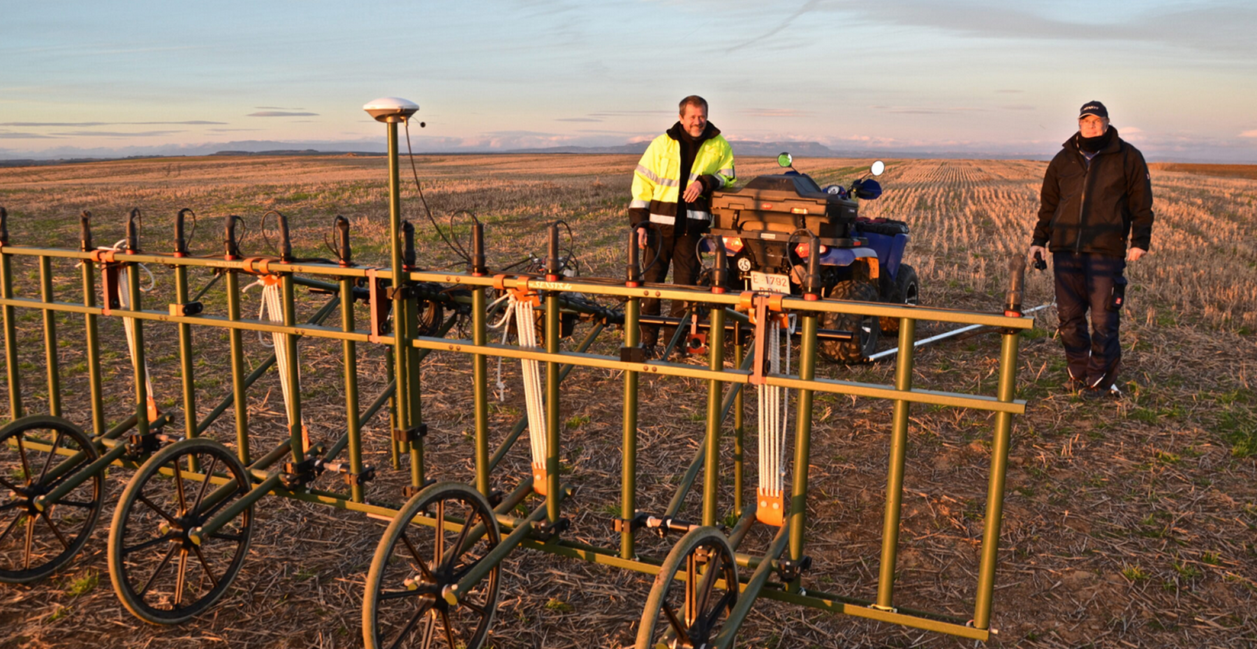
ARES was delivered jointly by SENSYS, the Fraunhofer Heinrich Hertz Institute HHI and UseTree. SENSYS further developed the sensor technology for field use. Fraunhofer HHI researched data analysis methods and spatial AR assistance tools.
UseTree developed the UX concept for the mixed reality application. The focus was on how measurement data, spatial guidance and interaction needed to work together to support specialists during a survey.
Many regions across Europe still contain buried explosive ordnance left behind by past wars or military exercises. It puts people at risk and restricts the use of affected land. Before construction or groundworks begin on potentially contaminated sites, the risk must be assessed.
Explosive ordnance detection is a complex, safety-critical process. Specialists must systematically survey sites, interpret measurement data reliably and make decisions in the field. How can digital assistance systems support them?
This was the question addressed by ARES, a research project funded by the German Federal Ministry of Education and Research (BMBF). The German acronym stands for “Augmented Reality Assistance Technologies for Optimising Safety and Efficiency in Explosive Ordnance Detection”. The aim was to combine advanced sensor technology, AI-assisted data analysis and augmented reality, making measurement data visible and usable directly within the working environment.
ARES was delivered jointly by SENSYS, the Fraunhofer Heinrich Hertz Institute HHI and UseTree. SENSYS further developed the sensor technology for field use. Fraunhofer HHI researched data analysis methods and spatial AR assistance tools.
UseTree developed the UX concept for the mixed reality application. The focus was on how measurement data, spatial guidance and interaction needed to work together to support specialists during a survey.
Many regions across Europe still contain buried explosive ordnance left behind by past wars or military exercises. It puts people at risk and restricts the use of affected land. Before construction or groundworks begin on potentially contaminated sites, the risk must be assessed.
Explosive ordnance detection is a complex, safety-critical process. Specialists must systematically survey sites, interpret measurement data reliably and make decisions in the field. How can digital assistance systems support them?
This was the question addressed by ARES, a research project funded by the German Federal Ministry of Education and Research (BMBF). The German acronym stands for “Augmented Reality Assistance Technologies for Optimising Safety and Efficiency in Explosive Ordnance Detection”. The aim was to combine advanced sensor technology, AI-assisted data analysis and augmented reality, making measurement data visible and usable directly within the working environment.
ARES was delivered jointly by SENSYS, the Fraunhofer Heinrich Hertz Institute HHI and UseTree. SENSYS further developed the sensor technology for field use. Fraunhofer HHI researched data analysis methods and spatial AR assistance tools.
UseTree developed the UX concept for the mixed reality application. The focus was on how measurement data, spatial guidance and interaction needed to work together to support specialists during a survey.
Challenge
During magnetic surveys for explosive ordnance, sensors detect minute changes in the magnetic field. These can indicate the presence of metallic objects underground. Specialists must assess the measurement data to determine whether a signal could indicate explosive ordnance.
Data collection and analysis often take place at different times and locations. While field teams collect measurements, detailed analysis follows later. Further investigations may require additional site visits.
The challenge was to make relevant information available during the survey itself. It needed to be understandable in the field and fit into a workflow that demands close attention and precise working practices.
How can measurement data and assistance functions be presented to support specialists directly as they work?
Starting point
In the established workflow, measurement data is collected in the field and subsequently processed, visualised and interpreted by specialists. Digital assistance systems offer an opportunity to bring these stages closer together. Information about measurement quality, areas already surveyed or unusual signals can provide support during data collection.
However, simply displaying more information is not enough. What matters is which information is needed in each situation. It must be clearly linked to its physical location and easy to take in without compromising awareness of the surroundings or the task at hand. This was the starting point for UseTree’s UX concept.
Challenge
During magnetic surveys for explosive ordnance, sensors detect minute changes in the magnetic field. These can indicate the presence of metallic objects underground. Specialists must assess the measurement data to determine whether a signal could indicate explosive ordnance.
Data collection and analysis often take place at different times and locations. While field teams collect measurements, detailed analysis follows later. Further investigations may require additional site visits.
The challenge was to make relevant information available during the survey itself. It needed to be understandable in the field and fit into a workflow that demands close attention and precise working practices.
How can measurement data and assistance functions be presented to support specialists directly as they work?
Starting point
In the established workflow, measurement data is collected in the field and subsequently processed, visualised and interpreted by specialists. Digital assistance systems offer an opportunity to bring these stages closer together. Information about measurement quality, areas already surveyed or unusual signals can provide support during data collection.
However, simply displaying more information is not enough. What matters is which information is needed in each situation. It must be clearly linked to its physical location and easy to take in without compromising awareness of the surroundings or the task at hand. This was the starting point for UseTree’s UX concept.
Challenge
During magnetic surveys for explosive ordnance, sensors detect minute changes in the magnetic field. These can indicate the presence of metallic objects underground. Specialists must assess the measurement data to determine whether a signal could indicate explosive ordnance.
Data collection and analysis often take place at different times and locations. While field teams collect measurements, detailed analysis follows later. Further investigations may require additional site visits.
The challenge was to make relevant information available during the survey itself. It needed to be understandable in the field and fit into a workflow that demands close attention and precise working practices.
How can measurement data and assistance functions be presented to support specialists directly as they work?
Starting point
In the established workflow, measurement data is collected in the field and subsequently processed, visualised and interpreted by specialists. Digital assistance systems offer an opportunity to bring these stages closer together. Information about measurement quality, areas already surveyed or unusual signals can provide support during data collection.
However, simply displaying more information is not enough. What matters is which information is needed in each situation. It must be clearly linked to its physical location and easy to take in without compromising awareness of the surroundings or the task at hand. This was the starting point for UseTree’s UX concept.
Process
The project produced a demonstrator that combines the collection, analysis and spatial visualisation of measurement data.
SENSYS’s magnetic sensor technology provided the field measurements. Fraunhofer HHI developed methods for processing and AI-assisted reconstruction of magnetic field data, alongside spatial AR assistance tools.
UseTree developed the UX concept for the mixed reality application. This covered which information specialists need in different working situations, how it is displayed within their field of view and how they interact with the application. The concept connected the technical functions with the requirements of the workflow.
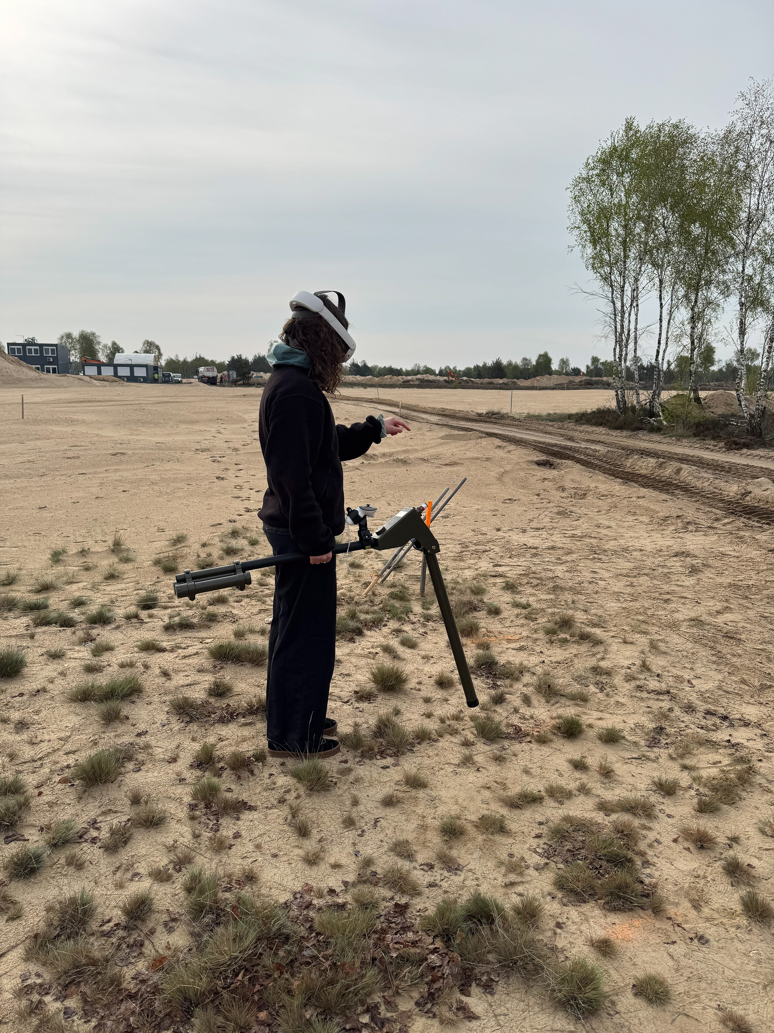
AR glasses enabled survey tracks, guidance and analysis results to be displayed directly within the user’s field of view. This linked the information to the area being surveyed. Specialists could see which areas had already been covered and where further attention was required.
Feedback on walking speed and measurement quality also formed part of the assistance concept. The demonstrator therefore combined guidance in the field with ongoing data collection and analysis.
UseTree designed how specialists interact with the mixed reality application and use the available information during a survey.
Process
The project produced a demonstrator that combines the collection, analysis and spatial visualisation of measurement data.
SENSYS’s magnetic sensor technology provided the field measurements. Fraunhofer HHI developed methods for processing and AI-assisted reconstruction of magnetic field data, alongside spatial AR assistance tools.
UseTree developed the UX concept for the mixed reality application. This covered which information specialists need in different working situations, how it is displayed within their field of view and how they interact with the application. The concept connected the technical functions with the requirements of the workflow.
AR glasses enabled survey tracks, guidance and analysis results to be displayed directly within the user’s field of view. This linked the information to the area being surveyed. Specialists could see which areas had already been covered and where further attention was required.
Feedback on walking speed and measurement quality also formed part of the assistance concept. The demonstrator therefore combined guidance in the field with ongoing data collection and analysis.
UseTree designed how specialists interact with the mixed reality application and use the available information during a survey.
Process
The project produced a demonstrator that combines the collection, analysis and spatial visualisation of measurement data.
SENSYS’s magnetic sensor technology provided the field measurements. Fraunhofer HHI developed methods for processing and AI-assisted reconstruction of magnetic field data, alongside spatial AR assistance tools.
UseTree developed the UX concept for the mixed reality application. This covered which information specialists need in different working situations, how it is displayed within their field of view and how they interact with the application. The concept connected the technical functions with the requirements of the workflow.
AR glasses enabled survey tracks, guidance and analysis results to be displayed directly within the user’s field of view. This linked the information to the area being surveyed. Specialists could see which areas had already been covered and where further attention was required.
Feedback on walking speed and measurement quality also formed part of the assistance concept. The demonstrator therefore combined guidance in the field with ongoing data collection and analysis.
UseTree designed how specialists interact with the mixed reality application and use the available information during a survey.
Impact
ARES demonstrated how digital assistance can support explosive ordnance detection. The demonstrator brought sensor technology, AI-assisted analysis and spatial visualisation together in a single system. UseTree’s UX concept defined how these functions could be accessed and used within the working environment.
Survey tracks and analysis results could be linked directly to the physical surroundings. Guidance and measurement quality feedback supported the survey process, bringing the use of data closer to the point of collection.
For infrastructure and construction projects, this offers the potential for more targeted investigations and faster site assessments. Linking measurement data to its spatial context also provides a basis for traceable documentation.
The research project resulted in a demonstrator. It showcases the assistance functions developed and provides a foundation for further testing and their transition into practical use.
Outlook
ARES has laid the foundation for advancing explosive ordnance detection through digital assistance. The next step is to develop the demonstrator into a practical solution and prepare it for market readiness.
A follow-on project is currently being prepared. The focus is on further testing under real operating conditions, technical development and establishing a viable business model.
We welcome discussions with potential users, strategic investors and companies interested in contributing capital, industry expertise or market access. Together with the project partners, we aim to turn the research results into a marketable solution.
Specialists and research partners are also invited to contribute their experience and support further development.
Further information:
Impact
ARES demonstrated how digital assistance can support explosive ordnance detection. The demonstrator brought sensor technology, AI-assisted analysis and spatial visualisation together in a single system. UseTree’s UX concept defined how these functions could be accessed and used within the working environment.
Survey tracks and analysis results could be linked directly to the physical surroundings. Guidance and measurement quality feedback supported the survey process, bringing the use of data closer to the point of collection.
For infrastructure and construction projects, this offers the potential for more targeted investigations and faster site assessments. Linking measurement data to its spatial context also provides a basis for traceable documentation.
The research project resulted in a demonstrator. It showcases the assistance functions developed and provides a foundation for further testing and their transition into practical use.
Outlook
ARES has laid the foundation for advancing explosive ordnance detection through digital assistance. The next step is to develop the demonstrator into a practical solution and prepare it for market readiness.
A follow-on project is currently being prepared. The focus is on further testing under real operating conditions, technical development and establishing a viable business model.
We welcome discussions with potential users, strategic investors and companies interested in contributing capital, industry expertise or market access. Together with the project partners, we aim to turn the research results into a marketable solution.
Specialists and research partners are also invited to contribute their experience and support further development.
Further information:
Impact
ARES demonstrated how digital assistance can support explosive ordnance detection. The demonstrator brought sensor technology, AI-assisted analysis and spatial visualisation together in a single system. UseTree’s UX concept defined how these functions could be accessed and used within the working environment.
Survey tracks and analysis results could be linked directly to the physical surroundings. Guidance and measurement quality feedback supported the survey process, bringing the use of data closer to the point of collection.
For infrastructure and construction projects, this offers the potential for more targeted investigations and faster site assessments. Linking measurement data to its spatial context also provides a basis for traceable documentation.
The research project resulted in a demonstrator. It showcases the assistance functions developed and provides a foundation for further testing and their transition into practical use.
Outlook
ARES has laid the foundation for advancing explosive ordnance detection through digital assistance. The next step is to develop the demonstrator into a practical solution and prepare it for market readiness.
A follow-on project is currently being prepared. The focus is on further testing under real operating conditions, technical development and establishing a viable business model.
We welcome discussions with potential users, strategic investors and companies interested in contributing capital, industry expertise or market access. Together with the project partners, we aim to turn the research results into a marketable solution.
Specialists and research partners are also invited to contribute their experience and support further development.
Further information:


Lorem ipsum dolor sit amet, consectetur adipiscing elit. Suspend Varius Enim in Eros Elementum Tristique. Duis cursus, mi quis viverra ornare, eros dolor interdum nulla, ut commodo diam libero vitae erat.
Lorem Ipsum Dolor Sit Amet